
|
|
|
|
Up to George and Jean's Holidays and Pastimes
|
|
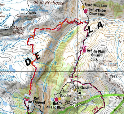
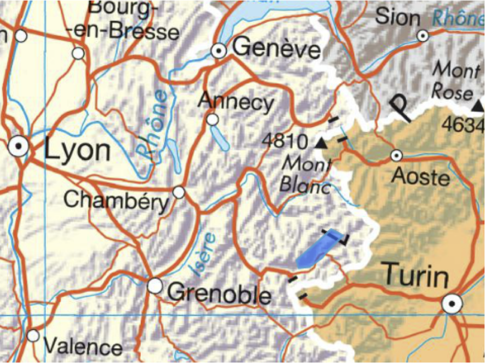
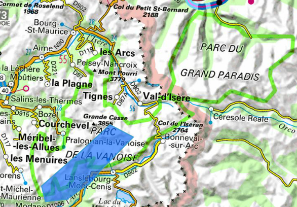
In 2012, we had our first walking holiday in The Parc National de la Vanoise (PNV, shown in the map on the right). We were very impressed by the close up views of the glaciers, the variety of wild flowers, the tameness of the marmots and the possibility of seeing a bouquetin. So we decided to return for another walk.
To experience the best of the mountains, we find that it's best to spend the night at around 2000m so as to be on the spot. For this purpose the refuges in the PNV are ideally situated. They can be accessed via the long distance walking routes GR5 and GR55. They provide full board and packed lunches for about €50 per person per night.
We decided to continue on GR5 from where we had left off in 2012. We planned our route using the Cicerone Guide "Tour of the Vanoise" which we took with us for details of each stage. For the details of the routes, we used the IGN hiking map 1:50,000 "Vanoise". We booked all of the refuges in advance using information available on their websites which are linked below.
We caught a Eurostar from London St. Pancras at 08.35, connected (just) to a TGV from Gare de Lyon in Paris at 12.40 arriving in Grenoble a bit before 4pm. We picked up a Fiat 500 from Sixt, and then drove to Aussois in the Maurienne Valley for our first night's stay.
Aussois is a small ski resort conveniently situated nearly 1000m below the point where we planned to start our walk. We enjoyed an excellent evening meal and comfortable bed at the very congenial La Roche du Croué which is in the centre of the village. The next morning, we left the hire car in the car park next to the church and left some of our heavier belongings in the boot for the duration our hike. The next morning we took the Telesiege du Gran Jeu up to about 2000 m. Our first overnight was at Refuge du Plan Sec (2350 m). It is almost directly above Aussois and the nearly 900 m walk on roads and tracks up past the two reservoirs would have taken the best part of the day and been rather boring.
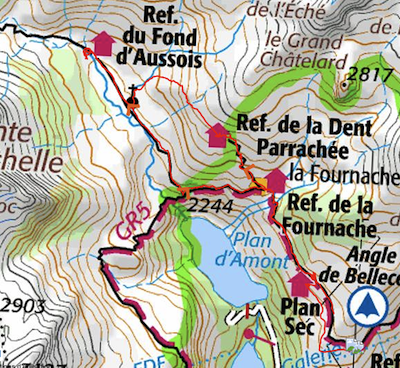
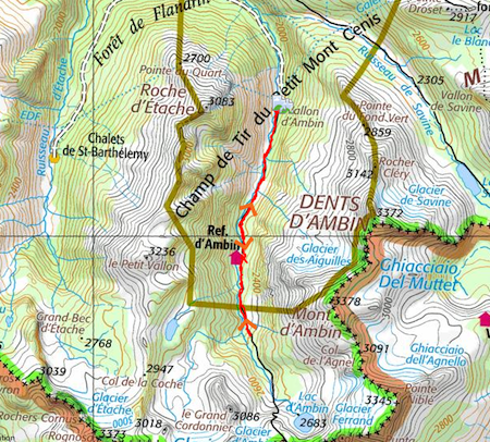
We were really pleased to be given the same tiny two-person room as last year at this very picturesque refuge. We decided to accilimatise ourselves by spending our first day in the mountains doing a walk from Refuge du Plan Sec . The map on the right shows our route as a thin red line and the GR5 as a line of thick red dashes.
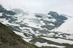
Our first walk was a circuit of about 13 km, starting on the path to Lac Génépi (which we saw last year), passing the refuge Fournache and stopping for a picnic lunch at refuge Dent Parraché (2511m). We were very surprised to have to cross a névé (snow field) to reach the latter. We sheltered from heavy rain and then set off up a new path round the contour where we saw marmottes and our first alpine flowers (yellow gentian, blue gentians large and small). On turning a corner we could see a green valley with a rushing stream below us.
We scrambled down the path to the valley, crossed a bridge, stopped by the tiny Chapel N-D des Anges and then turned upstream to Refuge Fond d'Aussois (2324m) where we enjoyed hot chocolate and myrtille tart. The second half of our circuit followed the stream down a very flat wide green valley with mountains on each side (Dent Parrachée and Point de l'Echelle), continued back down past the chapel and to the bridge on GR5 at La Sétéria above the waterfall that drops down to the higher reservoir (Plan d'Amont). The familiar GR5 leads back to Plan Sec, passing wonderful flowers: centauré, joubarbe (photo left)...
Our first day of moving-on along the GR5 took a route round the Angle de Bellecote, passing first above Sollières in the Maurienne Valley and then above the deep Gorge Doron. We knew this was a long way and thought the height gain would be within our grasp. But we found it tough! The walk took us maybe 9 hours and we arrived exhausted. But the path was beautiful and quite wild in places. We were amazed by the ubiquity of the white flowered dwarf bushes (Dryade à huit pétales) in the early part of the walk.
We set off at 7.45, progressing well for the first three hours. We passed waypoints la Turra and La Loza at the suggested times. We had been asked not to step on the Edelweiss up here and were amused to note that the only one we saw was surrounded by some protecting stones. We stopped for a snack while we waited for an enormous flock of sheep to pass, guided by several sheep dogs and a shepherd(ess) carrying an injured lamb (photo). The next section of path was on the side of a hillside with scrubby grass and scattered rocks, but was decorated by some quite creative cairns. The Maurienne Valley looked far away below. We were surprised to have to walk across a little névé – not a steep one and the footprints were well stuck in and perhaps melting a bit.
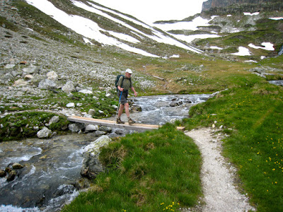
A little before our lunch stop we used stepping stones to cross the first big waterfall of the day. Many more were to follow. But between the waterfalls the path passed through some very verdant hillsides. We were astonished to see a big beautiful white flowered shrub (later identified as Asphodel blanc); it was about a metre high, the long white flower buds were clustered round a thick stem and each bloom ws like a six-pointed star. A little further on, the mountainside was covered with bright pink flowered dwarf rhododendron bushes. After crossing numerous spurs between the waterfalls, we caught sight of the Doron Gorge below us on our right.
As the clouds were building up, we hurried on, looking for somewhere to shelter. We eventually slotted ourselves in under a big rock and consumed most of the contents of the excellent lunch pack provided by the guardians at Plan Sec. When we set off again, we were able to keep dry with our little white waterfproofs but our poor sunhats were saturated – covers would be a good idea. Visibility was poor, so we failed to enjoy views of the glaciers (e.g. Arpont) on our left but as we approached the refuge we could see through thick cloud a helicopter delivering materials for the reconstruction.
Refuge de l'Arpont is in a good position above the Gorge Doron. There are also some pretty waterfalls just above the site. But due to building works we had to make detours even to get in and then wait a long time before seeing the guardian. New 6-person dormitories have been built, but the only sleeping space left was a pair of bunks; neither of us wanted to go up top, so we put both mattresses in the lower bunk. Unfortunately the bathrooms were almost non-existent - two squat-down toilets for 40 people and 1 wash basin - no showers. The guardians were struggling with catering in a temporary hut.
In the evening we chatted with two young women from Yorkshire who are doing Tour de Vanoise in 3 days (taking double stages each day and mostly running).
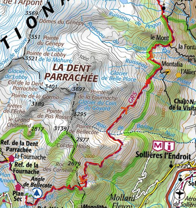
Our second day's walk on the GR5 continues along the east side of Gorge Doron (mainly above about 2400 m), then at the head of the gorge drops down to the valley of Entre Deux Eaux, where the Doron meets the Rocheure. The main (unexpected) feature was the large number of névés we had to cross. Only one of the névés was really steep but many were quite wide and most were on a slope. In the past we had always succeeded in planning routes that don't have névés in July, so were rather taken aback. We crossed so many that we lost count. George's foot went through the edge of one névé, causing him to fall and cut his wrist on the ice. All of this may be an explantion for the enormous time we took to get to Entre Deux Eaux.
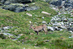
But the day had several rewards. The first was the appearance of a young bouquetin on the path in front of us (photo). We had only seen bouquetins in the distance before. It continued to approach us and then stood a little way off, allowing us plenty of time to take photos of it. The second was the close up view of glaciers (la Rechasse and La Roche Ferran). Another reward was the beauty of the ground around us at the highest place (around 2550m) where we stopped for a snack, surrounded by little lakes and a covering of violets and the rather mossy plants with pink flowers (le silène acaule) and the bright pink flowers peeping out between rocks (Saxifrage à feuilles opposées). And also the beautiful natural rock gardens (with joubarbe).
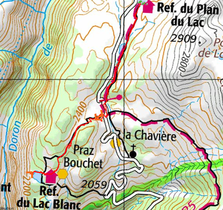
As we set off from Refuge Arpont, we could see Refuge Lac Blanc (where we stayed last year) on the other side of the gorge. The rather rocky path ascended and gradually approached the top of the gorge. After the névés, we found several large waterfalls to cross over – the larger ones had little plank bridges. At about 2pm, we reached Mont de la Para, where the link to GR55 joins our path. We started on the path down towards Entre Deux Eaux. On the way down we saw many black choughs – we'd learned to recognise them last year. And then meadows with centaurée, asters, scabious, yellow gentians, geranium and a few ferns. The zig zag descending path continued via farm land with hay and cattle and seemed never to be going to end. When we reached the bridge, we noticed that the navette was waiting, so used it to complete the journey to Refuge Plan du Lac (by road rather than on the footpath).
The Refuge of Plan du Lac is on the small road that runs down via Bellecombe parking to Termignon, about 1 hour's walk above Bellecombe parking. Only the navette and a few farm vehicles are allowed above the parking. It is a very comfortable modern refuge in a meadow and has views of the peaks and glaciers on the other side of Gorge Doron, as well as peaks to the north and west. Inside the refuge is comfortable, with dining and sitting room and indoors showers and loos. We were given two bottom bunks in a room for 6 people.
In the evening we chatted with a friendly couple from Marseilles and a woman who works for the PNV (Park Nation de la Vanoise). Then they showed a film about the PNV – the farming, the plants and the animals.
In 2012, we had stopped for a coffee at Refuge Plan du Lac on our way down to Bellecombe after a 4-day walk via Refuges Lac Blanc, de la Leisse and Femma. We had identified Plan du Lac as a comfortable place to spend two nights so as to have a break in our walk on the GR5. Plan du Lac has a lot of passing trade from people doing day walks after parking their cars at Bellecombe.
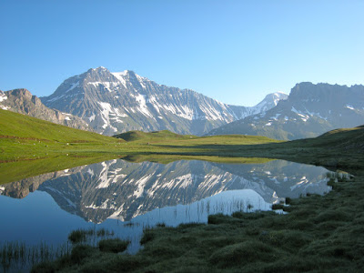
This time, we spent some time in the area surrounding the refuge, reading the information panels and learning the names of the peaks and glaciers that surround the refuge. La Grande Casse (to the north) at 3855m is the highest peak in Savoie; next to it is la Grande Motte (3653m). To the east is an impressive succession, starting with la Dent Parrachée (3639m)at the southern end (left in our photo). Next to it Glacier Pelve, Mont Pelve and Pte de la Rechasse. What isn't apparent is that the Doron gorge runs along in front of this range of mountains behind the green hillside in the foreground. Behind the refuge to the west are the cathedral-like spires of Pointe de Lanserlia.
We spent the rest of the day with a walk to Lac Blanc which is on the edge of the Doron gorge, not far beyond Refuge Lac Blanc. We found a perch above the lake on the edge of the gorge where we had a light picnic. We could see down to the bottom of the deep gorge and could spot Refuge Arpont on the other side. Then we had a swim in the lake (as we had done in 2012) – it really wasn't any colder than the sea on the south coast of England, maybe about 16 degrees? But people we mentioned it to said they thought we were mad. We stopped for hot chocolate and fruit tart at Refuge Lac Blanc, but didn't chat with the wardens as they seemed very busy with feeding passing walkers.
In the evening, at the meal we were challenged about the UK attitude to Europe – they see us as trying to get what we want out of membership whereas the French and Germans (at least) are trying for a joint project. After the meal we attended a slide show by Thierry - the PNV scientist (accompagnateur). We learned about wolves, bouquetin and glaciers melting. He kindly spoke slowly for us and the italian visitors, but was rather zealous in answering questions.....
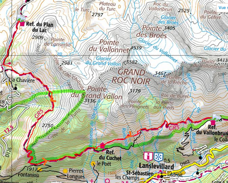
The Cicernone Guide describes this day's route as long, but without too many ups and downs. The GR5 uses a path above the little road to go down to Bellcombe parking. It then turns left up the mountainside and follows the path around the ridge called Crete de la Turra (2470m), after this, the path follows the direction of the Maurienne Valley above Lanslevillard, roughly ENE.
After la Turra, the path descends through woods for a very long time - all this descending was quite hard on the knees. We passed numerous hikers struggling up the slope. In a clearing we saw our first blue clematis – Clématite des alpes. At 1950m we came upon a track (labelled as a 'piste' - presumably for skis) still in the forest. We searched for an ideal spot for a picnic – with shade and a view and eventually stopped under a small pine tree, just before the end of the forest.
The path then climbs steeply to Refuge Cuchet(2160) a small unmanned refuge, where unfortunately the water supply had been turned off. (Apparently we could have entered the refuge and turned on the water.) We then walked through some attractive meadows, full of flowers. The path then followed a contour on the side of a very steep slope, but in some places the path was damaged and we had to cross 'delicate sections' – all rather nerve-racking. After passing the path down to Lanslevillard, our path became very stony, but much more stable. We saw a group of horses – not parricularly wild looking – whose were they? Then we crossed several waterfalls, most of which had plank bridges. As the path descended, we reached a farming area, cows and roofs with large stone tiles (Lauzes, see photo). These tiles are not nailed down – just stay there because they are so heavy.
At last we reached Refuge de Vallonbrun (2270m). It's a small stone building with modern bathrooms. The dormitory is divided into bays with two pairs of bunks. We were lucky to have an entire bay to ourselves. The guardian Fred is very hospitable and having spent many years in Canada is keen to chat in English. The refuge faces a range of mountains to the south – Pointe de Ronce (3612) and Glacier de l'Arcelle Neuve. On the other side, behind the refuge is the range of mountains in front of Refuge Femma (where we stayed last year), topped by Grand Roc Noir. We had an excellent meal (with salad – very welcome after several days without) and chatted with three women who were doing the tour of Haute Maurienne. They had been up to see the engraved rocks at Pierre au Pied accessible from a path that we had passed on the way down to the refuge. Early to bed.
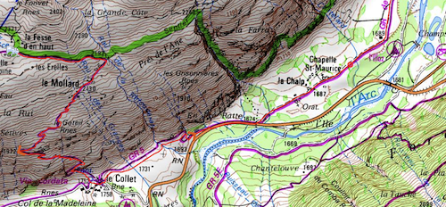
On this day, we completed the last stage of our walk on GR5 by walking down from Refuge du Vallonbrun to Bessans. The GR5 descends to the valley (Maurienne) here because there is no way of continuing at the higher level (say, 2000m) due to the steepness of the mountainside. In the afternoon, we retrieved the hire car from Aussois and then went to le Suffet on the other side of the Maurienne Valley where we planned to stay for three nights.
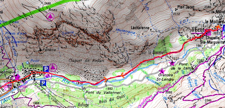
We made a slow start to the day, looked at the farms surrounding Vallonbrun and then took the path past Chapel St Antoine. The path went down, down, down to le Collet at 1752m. Here we stopped for a bit and met a friendly woman from Paris who stays each summer in the family home in Bessans. She advised us to follow the path via le Chalp. This path runs along the valley, parallel to the road, for a little while on it and then beside a stream on the way into Bessans. On the way we passed a very tall waterfall (photo). Farmers were cutting hay in the small fields beside the path. We left the GR5 and followed a small track over a bridge to enter Bessans.
In Bessans we checked the times for the navette that runs from Bonneval sur Arc via Bessans to Termignan. Wile we were easting a salad and ice cream in a café opposite the Mairie, the rain started. We learned that Bessans was destroyed in 1944 but rebuilt in traditional style. The chapel of St Antoine (a different one) next to church has frescoes on exterior walls. Both closed. Took 2:40pm (€1) navette to Termignon and then Taxi Marius to Aussois (23€).
We picked up the hire car from the parking place beside the church in Aussois and drove to Bessans then turned off on the southern side of the Maurienne Valley and went up the hill via le Planey to le Suffet. We stayed in Refuge gite du Suffet which is at 1700m on the mountainside below Lac du Mont Cenis (not far from the Italian border). We had chosen this location so as to see the mountain on the eastern side of the Maurienne valley and to be free to take some easy walks without moving on. Le Suffet turned out to be a very comfortable place to stay – we had an en suite room and the use of a sitting room with views of the mountains. We were the only guests (as the phone had been cut off). Le Suffet is run by Louis Damevin who sat with us at the meal which he also prepared. We had salad, sauté potatoes with ham, cheese, creme caramel, tisane (serpolet = wild thyme) and génépi.
A stream runs all the way down the Vallon d'Ambin, past le Suffet and le Planay and eventually joins the Arc river at Bramans. This stream starts from Lac d'Ambin (2663m) close to the Italian border (where the col is at 2829) and runs due north past the Refuge d'Ambin (2270m) and down to le Suffet where the valley swings round to the left.
We decided to drive up the Ambin valley until the road runs out at Maroqua parking place and then to walk up the valley, getting lunch at the refuge and hopefully reaching the lake.
The route following the stream is fairly easy to follow thanks to the many cairns, which are some of the most imaginatively constructed ones we've seen (photo). But the ground is very rocky and progress was made by clambering rather than walking. The lower part of the valley is very verdant with many alder bushes, some big plants with yellow flowers with composite heads and thin leaves (identified as Gaillet jaune). We saw some stunning blue alpine acquilegias (Ancolie commun) and large yellow daisies.
Further up the valley was drier but there were still plenty of flowers including the very colourful dwarf rhododendrons, cinquefoil and yellow violets. Perhaps the most interesting was a small pale blue campanula with divided petals (Campanule de Mont Cénis).
We paused at the refuge on the way up, deciding to return for lunch. As we got higher, the stream became noisier and the ground became steeper and more rocky. We passed the path that goes to Lac Noir and decided to turn round at about 2400m, lacking the motivation to scramble up to the lake. We stopped for a lunch of soup and cheese at the hospitable Refuge d'Ambin on the way down. After that we continued down hill beside the rushing noisy stream which only slows up by the hydro electric intake near Maroqua.
On our return we were very happy to relax in the sitting room at Le Suffet. We considered a walk for the next day – the route up to the Col of Petit Mont Cenis where Hannibal is supposed to have taken his elephants across into Italy. But reluctantly we arrived at the decision that we were too tired to walk again the next day. Another guest arrived: Alain, a school teacher (French literature). We enjoyed the discussions with him and another excellent the evening meal – which ended with delicious chocolate mousse flavoured by génépi.
As an alternative to another walk, we had decided to go to Bonneval-sur Arc for our last night. Bonneval is at the head of the Maurienne Valley, beyond Bresson. The GR5 continues along the valley from Bessans to Bonneval before turning to the north and then going up to the Col d'Iseran and on to Val d'Isere. We wanted to consider Bonneval as a possible base for walks.
On the way, we stopped at Bessans where the church and chapel were open. The baroque church was not that impressive. But the chapel St Antoine contains a beautiful series of 15th century frescoes of the life of Christ set within local landscapes.
The traditional stone houses in Bonneval are grouped together below the hillside (photo). In the centre is the very picturesque Gite d'Etape where we failed to get a double room. The village is all very well preserved but appears to have become rather a tourist trap. We stayed in the Hotel Evette Glacier.
After lunch, we took the little walk along the riverside footpath to Ecot, rising from about 1700 to 2000m. Beside the path we spotted several Lys Martagon. Further up the grass in small fields had been cut and stacked by hand. Ecot is a hamlet of restored stone houses with lauze roofs, about 5km up the river from Bonneval. There appear to be several footpaths around Ecot.
In the evening, most of the visitors had departed and Bonneval seemed more peaceful. Although plenty of good walks are accessible, we're not yet sure whether it would be a good base for a walking holiday.
Although the diary above frequently mentions the day walks taking too long, we did enjoy this holiday as much as previous ones in the mountains. We are still overwhelmed by the excitement from the landscape and its flora and fauna that can be experienced when walking all day at 2000+m and far from any road.
We really appreciate the service offered by the refuges in their beautiful remote positions. But we wonder whether we should continue to use them when we find it impossible to use the top bunks! Now that we have recovered from our tiredness, it's hard to believe that we will not try another alpine walking trip next year.