|
|
|
|
Up to George and Jean's Holidays and Pastimes
|
|
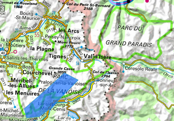
The Parc National de la Vanoise (see map right) was the first-established National Park in France. It is now one of three in the French Alps. We had walked in the other two (Ecrins and Mercantour) on other holidays so we were keen to visit the Vanoise. It covers an area of 1,250 sq km and the Parc National designation guarantees that it is as near to a wilderness as anything to be found in Western Europe with no entry for cars and no ski resorts. It is thus reserved entirely for hiking and as a domain for wildlife.
We have always enjoyed walking in high mountains and past holidays in the French Alps have been some of our most enjoyable. The term 'scenery' hardly does justice to the spectacular landscapes to be found in the Alps, composed of a huge variety of peaks, glaciers, valleys, meadows and torrents each one with a character of its own. The French word 'randonnée' describes a multi-day, moving-on walking tour and that is the sort of mountain hiking we most enjoy. But it had been 3-4 years since we had attempted one and we were concerned that the declining strength of our legs would limit our scope, so we decided on a plan consisting of two 3-day hikes with options for shortening them.
Alpine hiking is supported by the provision of 'refuges' and because we were planning to be there at a peak holiday time we had to book for each night in one. Refuges are large and often well-equipped mountain hostels, run throughout the summer months by guardians who always offer a warm welcome, a very nourishing evening meal and a bed in a dormitory. This type of holiday has grown in popularity in France and many refuges have been upgraded recently with 4 or 6-bed dormitories, plenty of showers and good sanitary facilities, but that certainly isn't guaranteed and we encountered others with 16-bed dormitories and a dearth of facilities.
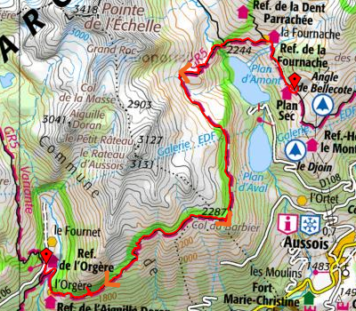
We caught a Eurostar from London St. Pancras at 07.48, connected to a TGV from Gare de Lyon in Paris at 12.40 arriving in Grenoble before 4pm. We picked up a hire car from Sixt, drove up the Grésivaudan Valley (familiar from our stays in the 1990s), turning right at Montmélian into the Maurienne Valley following the river Arc. We took the last exit before Modane and took a small winding road up the hill towards l’Orgère, arriving at a car park not far from the refuge at about 6:30pm.
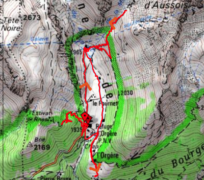
Refuge Porte de l’Orgère (1935m) is on the boundary of the Vanoise National Park which is entered by a rough track (at 1935m). Fortunately it faces into the park so one quickly forgets there is vehicle access. It is close to both GR5 which runs round the edge of the park and GR55 which goes across it. There are fine views of the peak of Aiguille Doran.
Orgère is a fairly modern refuge with 8-person dormitories, and toilets and showers adjacent. We insisted on bottom bunks and ended up sharing with a nice Danish family. The several women running this refuge are very friendly and produced excellent meals and picnics.
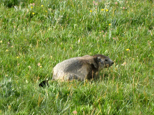
This was planned as a day for trying out the walking legs. We set off through the woods on GR55 towards Col de Chavière, surprised by the hundreds of butterflies. After a while we descended again and tried out the short 'sentier nature' which runs along both sides of the Orgère valley: the familiar blue campaniles were everywhere as well as knapweed, big yellow or white daisies. This valley is farmed: there are cows with bells and several stone buildings with thick stone roof slates; men were cutting the hay (we learned about the prés de fauche: a field with long grass and copious wild flowers that is about to be cut). We stopped for a picnic at the head of the valley where we were entertained by marmottes. George went on his own about 2/3 of the way up Col de la Masse and down again. On the way back, we stopped for tea at the refuge de l'Aiguille Doran – a stone building on a good site. After an excellent meal at the Refuge de l'Orgère, with a fondue made from Beaufort cheese, we were shown a film about marmottes.
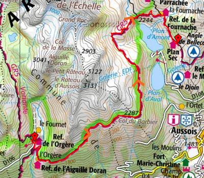
Our route followed the GR5 for a distance of about 17 km with quite a lot of ups and downs. We set off at about 8:30 on a steeply rising path that went through the woods for a long way. The sky was cloudy and the air quite cool. Eventually we emerged into an open alpage, reaching the cabanes de Barbier (2350m) at about 11 am. These shepherds' huts are in ruins but there's a modern house nearby with a shepherd in residence. The big flock of sheep was guarded by a barking dog even though the sheep were enclosed by a fence. We reached the Col du Barbier (2245) at about 11:30: it's more like a saddle than a conventional col. We descended a little to a picnic place where we were looking down at Plan d' Amont (one of two big reservoirs above Aussois). The clouds were just lifting and a passing walker pointed out the Refuge du Plan Sec in the distance across the reservoir - a long way still to walk.
The next phase of the walk was on fairly level open ground, rich with wild flowers (chardons des Alpes, rhododendrons, myrtille and genepi bushes…) and we were lucky in catching sight of a chamois on a slope to our left. We weren't quick enough to catch a photo with our compact camera though our walking companion Sidonie was able to with her telephoto lens. There was another climb up to the highest point of the day (2426m) at the intersection with a path to Col de la Masse. We had a rest and a second go at our generous picnic supplies from the refuge (couscous salad, chicken legs, crisps, cheese, roll, apple compote and biscuits). We were pleased to be above the two reservoirs, which were now out of sight replaced by views of small torrents tumbling down the steep slopes and converging on this spot. We now had clear views of La Dent Parrachée: a high snow-capped peak above Plan Sec and the other refuges on the other side of the valley.
We descended a rough path to the bridge of Séteria (2211m) at about 3 pm: an attractive location with a rushing river coming down the valley and heading for the reservoirs below. A final trudge up the path to a wide track at a level above Plan d' Amont brought us to the refuge du Plan Sec via a little path to the left.
Refuge de Plan Sec (2350 m) : a cluster of stone buildings at various levels that used to be a summer farm. The lowest building houses toilets and showers and a salle hors sac – a room where people who don't take the evening meal can warm up their own food. The middle building houses the dining room and kitchen, the top one houses a group of bedrooms of various sizes – we were very pleased to be given a tiny two-person room with a window at ground level outside and shoulder level inside the room. Very friendly wardens and good meals. There is a view down to the two reservoirs and around a corner, the top of a ski lift; but looking the other way there are very attractive views of the mountains.
We met some interesting walkers here: Sally and Noola (the only people we met from UK on these walks) who were doing a short tour of the Vanoise; Sidonie from Dijon who is walking long stages on her own and having trouble with new boots; a Dutch family with 6 and 9 year olds. Even before we went in for the meal it had become very cold outside. When we got up in the night there were bright stars and a big moon and clouds hanging in the valley above the lake.
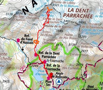
We didn't hurry, but eventually set off at about 10 am, first on yesterday's path, then turned up a steeper path to the Refuge de la Dent Parrachée, a timber building with cedar shingle roof, in an attractive setting but without the charm and atmsphere of Plan Sec. After a short rest there we followed the left of two paths uphill from the refuge in a succession of zigzags ('lacets'). Today's walk was probably the stiffest and the path climbed and climbed over a series of shoulders with no sign of the lake. Eventually we reached the lake just below the main patches of snow – we had seen a few smaller ones on our way up. The lake was shallow and muddy and nobody was swimming, so we just sat on a rock and consumed the picnic provided by the guardians at Plan Sec. We spotted two animals walking across the grass just below the glacier opposite: some said they were chamois, the Dutch family who went up to look at the glacier said they had seen many more but were told they were not chamois.
The walk down was enjoyable and we saw a very wide range of different wild flowers. We enjoyed the view while resting under the shelter of a big rock. The day was bright, but the wind was cooling. As we had plenty of time, we stopped at Refuge Fournache for crepes with marrons; this appears to be a recent building, constructed from rough stone with attractive timber shutters.
We were back at Plan Sec by 6pm in time to have showers before the arrival of a party of 30 alsaciens, i.e. people from Alsace (not dogs). At dinner time we were asked to have our meal in the Hors Sac room with the others not in that group: we met two more Dutch couples who have been holidaying together, walking a few stages of GR5 each year since they started out from Holland about 25 years ago.
It was time to retrieve the car from the Refuge de l'Orgère. We had to retrace the route we had taken two days ago along the GR5. We left Plan Sec at 8:30, getting down to Pont Séteria by 9:30, where we paused to enjoy the various views and get a panorama photo taking in our walk of the previous day to Lac du Génépi, Dent Parachée and the refuge at Plan Sec.
The slope up to the crossing of the paths above Plan d'Amont was quite steep but we quickly climbed past rhododendrons and reached the top by about 10:30. The traverse to Col Barbier seemed quite a long walk and did take us until 12:30. We selected a shaded vantage point under a lone pine tree for our picnic, although eventually we had to come out in to the sun to warm up. We left soon after 1 pm and walked over an extensive alpage covered in many very pale crocuses. At the Cabanes du Barbier the sheep and the dog were no longer there, but a lone horse still was.
After entering the pine woods above Modane, the path went down, down, down seemingly much further than we had climbed when walking the same route in the opposite direction. The path dropped nearly 500 metres in 1.5 kilometres skirting the bottom of a cliff, with signs reading 'Danger of falling rocks for 100 metres, don't stop here!', before reaching a fork in the path where the route to Orgère suddenly mounts up a very steep slope. It was nice to come out into the open and cross the pastures up to Refuge de l'Orgère.
Down to Avrieux. Removing our boots with relief, we drove the car down to the village of Avrieux where we spent a night at La Grange Avrieux (A chambre d'hotes in a recently renovated old stone building) so as to have a soft bed and a shower with plenty of hot water. Avrieux was a little sleepy with only one restaurant - though we had a good meal at la Cascade. We were very disappointed that the baroque church of St Thomas de Canterbury (Thomas à Becket) only opens on Thursday afternoons. There are several well-known baroque churches in the area and a Chemin du Baroque tourist trail is widely advertised, but we do wonder how do people get to see the architecture.
We drove to Termignon along the quiet and scenic D83 road above the Maurienne valley, stopping to look at the Cascade St Benoit (a very tall waterfall falling into an attractive stream with a path on each side). We bought picnic food in Aussois (a village with a lot more life than Avrieux). We looked round inside the stone church which has lauzes (big slabs of stone) on the roof and an interior containing frescoes, paintings and painted wood altarpieces. For our picnic lunch we chose a nearby 'site archéologique' that has some potentially interesting prehistoric stone engravings, though they are hardly perceptible and have suffered from vandalism.
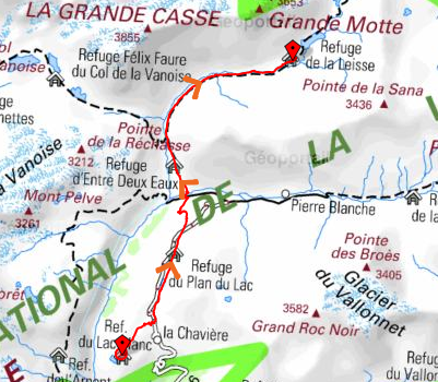
In Termignon we were able to visit Notre Dame de l'Assomption: a superb baroque church with a domed interior and a big golden altarpiece beyond the choir as well as painted wooden sculptures which had been taken down from the main beam across the choir arch. We were fortunate to be there while a piano trio were rehearsing. Finally we drove up to the Bellecombe parking place far above Termignon and set off on foot to take the 35 min walk to the Refuge du Lac Blanc.
We saw a tractor being used to cut the hay and flowers in a Pré de Fauche as we headed down to look at the lake. It was bigger than it looked and quite deep so we went in for a swim. The water wasn't even very cold - maybe 20 degrees? On the far side, there is a spectacular view down the huge gorge of river Doran.
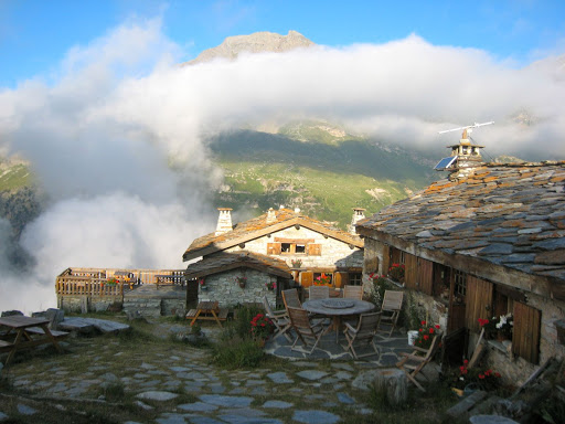
Refuge du Lac Blanc (2300m): is one of a group of stone buildings at a high point above a small lake. We were lucky to be the only occupants of the dorm with a shower and toilet en suite. It would have been rather hectic if all 18 beds had been occupied! The guardians Céline and Valerie gave us a good dinner (soup, sausages+potatoes, 2 cheeses (tomme savoie and beaufort) followed by banana cake). Unlike all the other refuges, they have no spring and have to sell bottled water.
After dinner there was a spectacular storm (thunder and lightening) which went on raging for an hour or so.
We walked back down past the Bellecombe parking area and then turned left up a wide valley (following the river Doran de Termignon) with the peaks of La Dent Parrachée and Pointe de la Rechasse on our left. From this side of the mountains, we could see glaciers on both of them. We passed above a small lake and stopped briefly to read the information panels outside the Refuge du Plan du Lac. We read about 'bourrelets': bumpy grass-covered areas below the glaciers that are composed of a mix of ice and stones. On the right are Clochettes de Lancerlia (a peak whose top consists of a line of black pointed rocks – looking like a cathedral from some aspects). We were advised to look for a flower la Dryad a huit pétales and we did indeed find one.
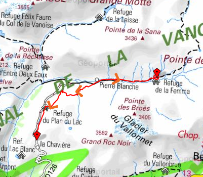
The valley seems very fertile above Plan du Lac: small bushes and hornbeam-like trees. We stopped for lunch by the chapel of St Pierre just above the Refuge de l'Entre Deux Eaux. A little further on, we joined the GR 55: the left path to Refuge Col de la Vanoise crosses a bridge over the torrent Leisse, whereas our path continues along and up the Leisse valley. By the bridge, we saw a family group with a donkey for portage.
We walked on a path above the torrent on a grassy hillside with scattered stones and a few interesting flowers as well as a coverage of clover, yellow daisies and campanules (harebells or small blue campanulas). We rested on a rock for 'tea' at 2250m and noticed we were surrounded by forget-me-nots. The big cliffs on the other side of the torrent were covered in scree, crowned with snow. Further on, our path crossed scree and then the torrent branches out. The last lap to the refuge is on a steep path up.
Refuge de la Leisse(2487m). This was the highest refuge we visited; it is on a hilltop with views down to the Leisse valley and across to the hills on either side. It is also a long way from the nearest road. Almost tame marmots run about nearby. The refuge consists of a group of tent-like timber buildings: at the top level are the dormitories, kitchen and dining blocks, the toilet and shown block is down a few irregular steps – rather a hazard at night, even with a torch. In case you need to know, these were the only squat-down toilets we encountered. The wash basin is out in the open beyond the kitchen block. The sleeping accommodation was tight: rucksacks have to be hung up near the door and used as storage. However, the guardians are very friendly, the meal was very good and there was a good atmosphere in the dining room. There was another dramatic storm after the evening meal.
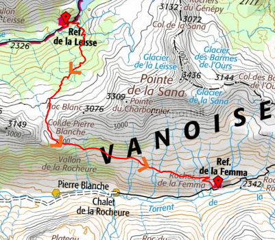
We waited for the other 16 people in our dorm to get up, but when we emerged there was still a heavy mist covering the refuge and the valley below - making us wonder whether our planned hike would be feasible. We enjoyed the breakfast which included some home-made cake. We planned to try to walk to La Femma (the next refuge) by a route over Col de Pierre Blanche to the next valley rather than by retracing our steps to the meeting point of the valleys at Entre Deux Eaux. The mist did lift quite soon and Céline (one of the guardians) explained how to find the unmarked route over the Col.
We set off at about 9 am, following sheep tracks across 3 torrents, then encountered a flock of sheep and rams. We used stepping stones to cross a stream. This phase was quite a struggle and we saw only one cairn but George's GPS helped us to check our route. We rested at the only clear waypoint on our map: a little lake at 2680m – these high-level lakes are always stunningly beautiful and this one, with its refections of mountains, snow patches and clouds didn't dispppoint us. We'd seen flowers all the way and asters by the lake. We noticed a new flower with small red petals (Ranunculus parnassifolius, we think). At this high level we saw thousands of little gentians in big patches as well as mountain vetches. We reached the col (2848m) at 11:45.
The path down the other side was more clearly marked and easy to see. For a long way, it was a narrow earthy track traversing a steep grassy slope. After a descent, the path turns left and runs high above the Vallon de la Rocheure. We had lunch perched on the grassy slope below the path, looking back to the glaciers to the east of us. We wandered on, passing our first clumps of Edelweiss and spotting a Jean le Blanc soaring below us. Jean le Blanc is a small eagle. We also noticed groups of Alpine Choughs gathering in quite large numbers. This was a very good path apart from one short schisty section. We had been advised to remain high until we saw the Refuge de la Femma and then to turn down. We followed a series of zigzags, spotting a herd of cows on the slope below before arriving at about 3:30.
Refuge de la Femma (2323m) This is a boarded timber building perched at the edge of a slope with a big balcony supported on posts above the downward slope. The dining area is in a spacious room on the ground floor. The 4-person bedrooms are upstairs: we had one to ourselves and were very comfortable. The showers, washrooms and toilets are adjacent. At meal time, each group sat at a separate table (like a hotel). The evening meal was very good and the breafast included cereal.
We set off early down the Vallon de la Rocheure: a very green valley with farms, sheep and cattle. After a couple of kilometres on a pleasant footpath we joined the rough track that runs the rest of the way down the valley (it's used by the farmer but, being well inside the park is definitely not for use by anyone else). We soon turned off the track onto a slightly rocky path up the hill below the Grand Roc Noir. We were very impressed by the view of the black spikey peaks of the Clochettes de Lancerlia above another rock - it looked very much like a cathedral. Our highest point was at 2431m, where we had a picnic sitting on rocks with a view of the range opposite: the glacier-topped Dome de l'Arpont and Mont Pelve which are to the north east of la Dent Parachée. We then followed an easy path down to the Refuge du Plan du Lac, where we stopped for coffees before going on to collect the car from the parking at Bellecombe.
It's hard to express the reasons for the intense pleasure that this kind of holiday gives us. Spending days on end in an unspoilt natural environment amongst some of the most spectacular mountains in Europe, completing arduous walks sometimes nearing one's physical capacity and then spending the evening in a hospitable and comradely environment, still surrounded by spectacular views while reflecting on the day's experiences and contemplating the next day's exertions, all contribute to the unique experience of a randonnée holiday!