Practicalities and Navigation
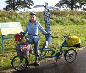
Our tandem and luggage
We have enjoyed organising and riding tandem tours in France and elsewhere for many years. Our current tandem was specially-constructed based on a Moulton APB small-wheel bike with suspension. Its advantages include its comfort due to the suspension, good luggage carrying facilities and the fact that the tandem splits for transportation when necessary - we didn’t need to split it on this trip, but the option to do so made us more confident when heading for a train.
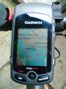
Navigation with the aid of a Garmin GPS device and Andy Allen’s OpenCycleMap data
Planning the trip
We planned to make a circular tour in the north of Ireland, starting and ending at Larne (on the coast, north of Belfast). We intended from the start to include Rathlin Island and Giants Causeway, spending a day exploring each. Originally we had hoped to include most of Donegal, but that route would have been over 800 km – more than we wanted to do in 10 days. We therefore decided to include only Inishowen in Donegal to cut it down to about 500 km. We drew the route on Google maps, which also gave us an estimate for each day’s travel.
For paper maps we use Sustrans maps of the route from Glasgow to Troon (NCN 75) and of the Antrim Coastal Route (NCN 93). We also took pages from the OS Road Map of Ireland.
We spent some time studying and copying details of B and B accommodation on the web and in Lonely Planet but we waited until the relevant day before reserving. Only once (at the Giant’s Causeway) did we discover that our first choice was full and needed to use the iPhone to find an alternative.
Daily Planning
The routes drawn on Google map were output and converted to a suitable form for input to our Garmin Edge 605 GPS device, which also had a full ‘routable‘ OpenStreetMap dataset for the UK and Ireland from the OpenCycleMap Shop. The GPS provided very reassuring cues whenever we were following one of our planned routes. On some days these were only a guideline as we often followed a marked Sustrans Route or chose one that looked good on the day or altered our plans. On the final day we followed a route from Mossley to Larne planned on the GPS and we were surprised to find that the route was of very high quality - thanks undoubtedly to the excellent level of completeness and accuracy that OpenStreetMap has now attained.
Plotting the route actually ridden
The GPS also logged the route of each days ride. These ‘tracks’ were uploaded to a computer and plotted on a Google map after conversion to the correct format. The results are seen as the maps shown at the top of many of the pages of this trip blog. They are also available for downloading as GPX files for use in Garmin and other GPs navigation devices.
Weather forecasts?
In Ireland it may be better not to see detailed weather forecasts for the days ahead. We used the iPhone to see predicted rainfall, wind strengths and directions etc for seven days ahead. So we would see gloom and doom ahead of us. What it produces on the day is often better than predictions; for example, we had a fine day in Scotland, riding to Troon while it was wet in Northern ireland. The next day, the rain moved over to Scotland.
On approach to Inishowen we were warned that there would be rainfall of 5 cms and winds against us of 35 kph or so for 3-4 days ahead. It was useful to be warned and to modify our plans, but in practice there was only one day when it rained all day and we found a sheltered route to avoid the worst of the wind force.